
Speeding up geospatial data collection with CEA: Part 2/3
This article is Part 2 of a series of posts dedicated to describe the Data Management tools of CEA.
Back in Part 1, I described how to gather technical and economic data for the are of your interest with the Data Helper tool.
In this post I talk about new tools called:
District Helper tool.
Terrain Helper tool.
These tools can help to automatically extract the geometry data of buildings and their terrain for virtually any location around the world.
Let’s start by talking about the District Helper tool.
The District Helper tool
The District Helper tool retrieves GIS information about the geometry of the buildings surrounding your zone of analysis in CEA. If you have not created your zone of analysis yet. I recommend to follow this tutorial, which describes how to create a new project in CEA and add your zone of analysis.
View fullsize

Blue: Zone of analysis in CEA, Red (RESULT): District or geometry of surrounding buildings in CEA
These data are extremely important, since they help you to account for over-shading in buildings when estimating the solar energy potential of your zone of analysis.
The data are gathered from Open Street Maps, so make sure you are connected to the internet.
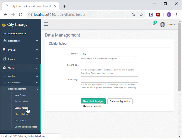
To use the tool, we will use the following steps:
Select a buffer: For this exercise we select 50 m, which represents the distance from your zone of analysis to the end of the surroundings we would like to get data from.
Select a height-ag: For this exercise we will leave the field empty. This will tell CEA to go ahead and get the height above ground of the surrounding buildings from OpenStreetMaps directly.
Select a floors-ag: For this exercise we will leave the field empty. This will tell CEA to go ahead and get the number of floors above ground of the surrounding buildings from OpenStreetMaps directly.
Run the CEA District Helper tool, and close the output messages screen once finished.
Use either CEA or any other GIS system to visualize the results.

Blue: Zone of analysis in CEA, Red (RESULT): District or geometry of surrounding buildings in CEA
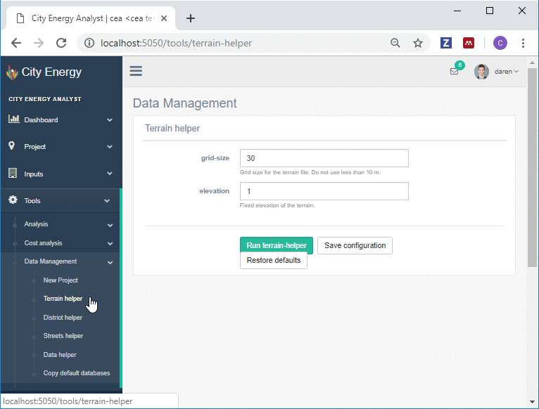
The Terrain Helper tool
Now, it is the turn for the Terrain Helper tool. This tool basically retrieves a digital elevation model of the terrain of your zone of analysis in CEA. Once again, if you have not created your zone of analysis yet, I recommend to follow this tutorial, which describes how to create a new project in CEA and add your zone of analysis.
View fullsize

Blue: Zone of analysis in CEA, Red: District or geometry of surrounding buildings in CEA, Grey (RESULT): Digital Elevation Model of the terrain.
The Digital Elevation model of the terrain is a raster file (an image), where every cell or pixel stores information about the average height at that point in space.
This information is quite important since it helps your simulations to account for solar radiation being reflected from/to the terrain to/from buildings. The CEA team has found that humid (Singapore) and dry (Abu Dhabi) cities are particularly sensitive to this data source.
Although the current version of the Terrain Helper tool works with a fixed elevation for the terrain, we will update the tool to download Satellite data with a close to real elevation. We will update this post when that is ready.
gif terrain helper.gif
To use the tool, you will need to create a New Project with CEA first, if you have not yet. After that, you can then follow the next steps:
Select a grid-size: For this exercise we select 30 m, which represents the height and width of every cell/pixel of the Digital Elevation Model. I recommend to keep it to a minimum of 10 m to not affect performance.
Select an elevation: For this exercise we will select 1 m.a.s.l, which represents the fixed elevation of the terrain.
Run the CEA Terrain Helper tool, and close the output messages screen once finished.
We can use either CEA or any other GIS system to visualize the results as follows.

Blue: Zone of analysis in CEA, Red: District or geometry of surrounding buildings in CEA, Grey (RESULT): Digital Elevation Model of the terrain.

Co-inventor of the City Energy Analyst
Project leader at EBP Schweiz.
Sep 8, 2018
If you liked this post, please give it a like or share it. Thanks!